The Appalachian Trail
The Appalachian National Scenic Trail, designated a linear National Park by the 1968 National Trails System Act, is a continuous, marked public footpath extending approximately 2,144 miles from Mount Katahdin, Maine to Springer Mountain, Georgia along the Appalachian Mountain range.
|
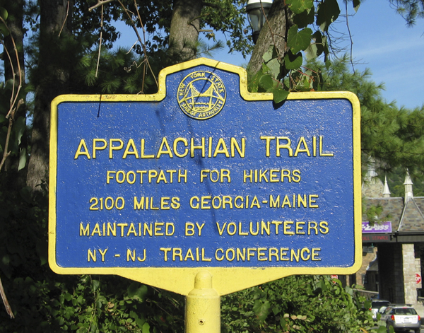
Click
to enlarge photo of Appalachian Trail Sign.
|
 The sign reads:
"APPALACHIAN TRAIL
Footpath for Hikers
2100 Miles Georgia-Maine
Maintained by Volunteers
NY - NJ Trail Conference"
Note:
Look for this sign on the Rockland side of the Bear Mountain Bridge tollbooths.
|
"The [Appalachian] trail maintains a wilderness character by following the scenic ridges of the Appalachian Mountain ranges of the White, Green, Berkshire, Ramapo, Kittatinny, Blue Ridge, Great Smoky, and Nantahala Mountains. The Appalachian Trail is protected along most of its course by federal or state ownership of the land. The entire trail environment is maintained as a place for everyone to hike and enjoy the Appalachian Mountains, while at the same time conserving the natural, scenic, historical and cultural resources of this one-of-a-kind, linear park."
Source:
Signage at the Visitor Center on the Palisades Interstate Parkway.
|
A Bit of History
In 1921, the idea for the Appalachian Trail originated with a volunteer forester Benton MacKaye. He conceived "
The Trail
" as a refuge from modern stresses, stretching along the spine of the Appalachian Mountains, where hikers could re-connect with the natural world. Once MacKaye's idea was published, over the years, volunteers from hiking groups in the Northeast made that dream a reality - a 2,144-mile-long hiking trail that became our nation's first National Scenic Trail.
Through a network of 32 hiking and trail clubs from Maine to Georgia, volunteers form the basis of a unique, volunteer-based, cooperative management system for this national parkland. Volunteers take an active role in safeguarding the quality of the Trail both for the hiking public and local communities. The private Appalachian Trail Conference oversees the volunteer effort along the Trail's length.
|
Click
to enlarge photo of the Bear Mountain Bridge.
|
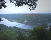 The roadway of the Bear Mountain Bridge carries the Maine-to-Georgia Appalachian Trail. The Bear Mountain Bridge has eight-foot-wide shoulders for pedestrians and cyclists to comfortably walk on both sides of the bridge.
|
Click
to enlarge photo of View of the Hudson River.
|
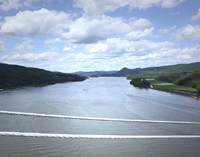 The photo of the Hudson Valley is taken from the northwest side of the bridge. Experience wonderful views of the majestic Hudson River when walking the Appalachian Trail on the Bear Mountain Bridge.
|
The Appalachian Trail enters New Jersey at the Delaware Water Gap National Recreation Area, and runs northward along the ridgeline of the Kittatinny Mountains to High Point State Park. There it strikes east along the NJ/NY state line, crosses the Wawayanda plateau, and enters New York state on the ridge overlooking Greenwood Lake. It traverses Harriman-Bear Mountain State Park (where the Appalachian trail was first conceived), crosses the Hudson River on the Bear Mountain Bridge, heading northeasterly towards and through Fahnestock State Park. Continuing northeast, it crosses into Connecticut near Kent, CT.
|
Click
to enlarge photo of Popolopen Creek from the Bear Mountain Bridge.
|
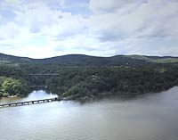 The Popolopen Creek Footbridge, a bridge for pedestrians only, connects the trail between the twin forts, Fort Montgomery and Fort Clinton, and carries the Appalachian Trail on the western side of the Bear Mountain Bridge.
|
Popolopen Creek
Popolopen Creek is a stream that is mostly fed by Lake Popolopen, Stillwell Lake, and Weyant's Pond. Eventually, the creek drains into the Hudson River. In 2002, New York's Governor George Pataki, dedicated a long suspension foot bridge that spans Popolopen Creek.
|