| |
Click
to enlarge photo of Bear Mountain Bridge Walkway
|  Bear Mountain State Park is located in Bear Mountain, New York within the Hudson River Valley, about 45 miles north of New York City. Bear Mountain Park, approximately 5,067-acres (20.51 km2), is heavily forested and is primarily a day-use park offering magnificent scenery, photo opportunities and hiking trails for all levels of hikers.
|
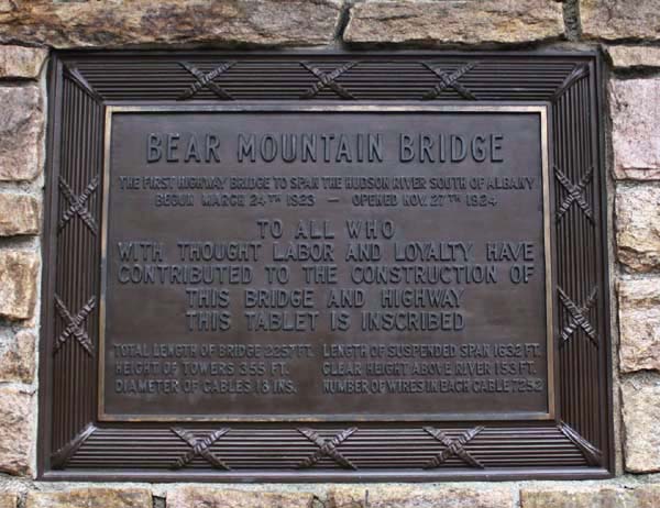
Bear Mountain Bridge
The Bear Mountain Bridge is a toll suspension bridge in New York State, carrying US-6 and US-202 across the Hudson River, from Bear Mountain State Park (at the northern tip of Rockland County) to the northwestern corner of Westchester County. The western approach to the bridge actually lies on the border of Orange County and Rockland County.
The Bear Mountain Bridge was completed in 1924; making it the longest suspension bridge in the world. A couple of years later, in 1926, the Benjamin Franklin (Philadelphia-Camden) suspension bridge became the longest suspension bridge in the world.
|
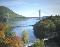
Click
to enlarge photo of the Bear Mountain Bridge Tablet.
| 
This Tablet hangs on the wall of the Bear Mountain Bridge Toll Plaza.
|
BEAR MOUNTAIN BRIDGE
The first highway bridge to span the Hudson River South of Albany
Begun March 24th 1923 - opened Nov. 27th 1924
To all who
With thought labor and loyalty have
Contributed to the construction of
This bridge and highway
This tablet is inscribed
| |
Total length of bridge = 2257 ft.
|
Length of suspended span = 1632 ft.
| |
Height of towers = 355 ft.
|
Clear height above river = 153 ft.
| |
Diameter of cables = 18 ins.
|
Number of wires in each cable = 7252
|
|
|
|
|
The roadway of the Bear Mountain Bridge has eight-foot-wide shoulders for pedestrians and cyclists. The bridge also carries the Maine-to-Georgia Appalachian Trail. Crossing the bridge on foot offers magnificent views, wonderful photo opportunities, and an invigorating walk. For equally beautiful views, walk both sides of the bridge.
From the walkway of the bridge, face northwest, and you can see 3 more bridges: the Popolopen Suspension Bridge, the Popolopen Creek Suspension Footbridge, and the MTA train tracks. All of these bridges cross
Popolopen Creek.
|
Click
to enlarge photo of View of the Hudson River from Bear Mountain Bridge.
| 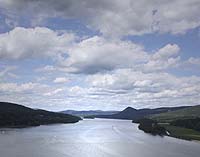
Look ahead, facing north, as the Hudson River moves toward the hamlets of Manitou, a Metro North train stop, and Garrison, also an MTA train stop. Garrison on the water faces West Point. Look east and you will see the mountain known as Anthony's Nose, 900 feet up.
|
The
Appalachian Trail
is America's first National Scenic Trail. The trail stretches from Katahdin in Maine to Springer Mountain in Georgia. It was originally conceived as a greenway between these states in the 1920's and has become the most popular trail for day-hikers and thru-hikers alike that want to see the scenic wonders of the Appalachian Mountains. The Appalachian Trail is approximately 2160 miles; it is a well-maintained hiking only trail and has shelters conveniently spaced for overnight stays.
Popolopen Creek
Popolopen Creek is a stream that is mostly fed by Lake Popolopen, Stillwell Lake, and Weyant's Pond. Eventually, the creek drains into the Hudson River. In 2002, New York's Governor George Pataki, dedicated a long suspension foot bridge that spans Popolopen Creek. The footbridge connects the trail between the twin forts of Fort Montgomery and Fort Clinton, carrying the Appalachian Trail on the western side of the Bear Mountain Bridge.
Popolopen Creek Suspension Footbridge
The Popolopen Creek Footbridge, for pedestrians only, was designed to create an economic and esthetically pleasing river crossing of 140m on the Appalachian Trail in Bear Mountain Park. You can access the bridge on a path near the Bear Mountain Bridge toll booths. However, the Popolopen Creek footbridge is most easily accessed through Fort Montgomery. Just park your car at the Fort Montgomery Visitor Center off 9W, north of the Bear Mountain Bridge, and walk down to Popolopen Creek.
The American Revolution in the Hudson River Valley
Fort Montgomery is just north of Popolopen Creek in Bear Mountain State Park. Fort Montgomery and its sister fort, Fort Clinton, were the scenes of fierce American Revolutionary War battles for control of the Hudson River and the Hudson Highlands. On October 6, 1777, the British captured both Fort Clinton and Fort Montgomery. Read excerpts from several moving accounts of the American Revolution and the battles that captured
Fort Montgomery and Fort Clinton.
Today, Fort Montgomery is an archeological site and a historic ruin. Fort Montgomery State Historic Site is a genuine vestige of our nation's struggle for independence. Visitors will see the actual foundations of the fort's buildings and remains of the fort's earthworks. Visit Fort Montgomery and tour the remains of the 14 1/2 acre fortification, perched on a cliff overlooking the Hudson River.
Things To Do on Walkway of the Bear Mountain Bridge
Appalachian Trail - Walkway takes the
Appalachian Trail across the Hudson River
Photo opportunities
Scenic views of Hudson Highlands
Short hike across Bear Mountain Bridge
Location: Bear Mountain - Rockland County
|