| ThingsToDoKids.com | ||
|
||
About the Long Path Hiking Trail |
|---|
|
This 350 mile hike, going south to north, extends from the George Washington Bridge in Fort Lee, N.J. to Altamont, N.Y. The trail crosses the Slide Mountain Wilderness; where you hike through the Peekamoose-Table Trail, the Phoenicia East Branch, the Curtis Ormsbee Trail, and then over Slide Mountain via the Wittenberg-Cornell-Slide Trail. The Long Path Trail is a challenging hike that offers easy to difficult trails within sections of the longer 350 mile hike. Distance: 350 miles - George Washington Bridge in Fort Lee, N.J. to Altamont, N.Y. Difficulty: Challenging hike. Sections of the Long Path Trail offer easy to challenging hikes. Markers: Light blue green (turquoise) Long Path Navigation
Long Path Hiking Guide"The Long Path takes advantage of the Catskill's extensive network of hiking and biking trails continuing north out of Slide Mountain Wilderness through parts of the Devil's Path and Escarpment Trail. The Long Path passes through the heart of the Catskill Mountains, bisecting the Preserve through Sundown Wild Forest, Slide Mountain Wilderness, Phoenicia Wild Forest, Indian Head Wilderness, Kaaterskill Wild Forest, Windham Blackhead Range Wilderness, and Elm Ridge Wild Forest."
Hiking the Hudson Palisades Trail on the Long Path
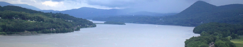
"The southernmost sections of the Long Path follow the Hudson River and the Hudson Palisades north, staying close to the river and to civilization. Although the trail does have some quiet forests and lakes, the majority of its scenic vistas look out over the Hudson River and the works of civilization. Its most impressive views encompass towns and villages along the way, but the most conspicuous ones are of the cities and villages on the east side of the Hudson River, not the least of which include the Borough of Manhattan and the City of Yonkers." . . . Continued (Press blue button for source of information).
Distance: 14.10 miles Trail Conference Maps 108 and 109 (Hudson Palisades Trails) "After crossing the George Washington Bridge, the Long Path follows the crest of the Palisades Escarpment on the western bank of the Hudson River near New York City, wandering between the cliff edge and the Palisades Interstate Parkway. The route affords stunning views of the basaltic face of the Palisades, the Hudson River and the City of New York and its suburbs." Distance: 10.3 miles Trail Conference Map 109 (Hudson Palisades Trail) "After following the Palisades through New Jersey, the Long Path continues into New York along the Palisades Escarpment. This section is a mix of state, county and town parks and some suburban road walking. The trail begins along US Route 9W in the hamlet of Palisades, continues to Tallman Mountain State Park, descends to the Village of Piermont, ascends to Mt. Nebo, Clausland Mountain Park, Tackamack Town Park, Blauvelt State Park, and Sean Hunter Ryan Memorial Park, and finally descends into Central Nyack." Distance: 8.85 miles Trail Conference Map 110 and 111 (Hudson Palisades Trail) "The first two miles of this section are suburban and the trail frequently runs along roads or near houses. After leaving US Route 9W, the Long Path ascends Hook Mountain. Its bare summit affords splendid views up and down the Hudson River. The trail then continues through woodlands and along ridges, passing an old cemetery and old quarries." Distance: 6.85 miles Trail Conference Map 112 (Hudson Palisades Trail) "In this section, the Long Path travels along little used roads for a mile, passes dramatic quarried cliffs of the Palisades, and then enters the woods and ascends High Tor. The ascent is often steep, with several good viewpoints. The open summit affords a 360-degree view up and down the Hudson Valley. The trail then descends from High Tor, ultimately passing Little Tor while following the ridge." . . . Continued (Press blue button for source information). Visit Long Path - Hudson Palisades for more about hiking this section of the Long Trail. Hiking the Hudson Highlands Trail on the Long Path
"The Long Path makes its first foray into genuine mountains as it passes through the Hudson Highlands. It is the first time that the trail reaches higher than 1000 feet elevation above sea level. As part of its journey north through this region, it traverses the length of two major New York State Parks, Harriman, one of the oldest, and Schunemunk Mountain, one of the newest." . . . Continued (Press blue button for source information).
Distance: 9.40 miles Trail Map 112 (Hudson Palisades Trails) and Trail Map 118 (Southern Harriman-Bear Mountain Trails) "The Long Path heads north along the Palisades Interstate Parkway for about a mile, crosses the South Branch of Minisceongo Creek, turns west, and climbs up the side of Cheesecote Mountain before descending past Cheesecote Pond and Letchworth Village Cemetery. The trail briefly follows Call Hollow Road before turning west into Harriman State Park. Harriman State Park is a stunningly beautiful preserve of lakes, hemlock and hardwood forest, historical trails and sites, wetlands, mountains and ridges. On the portion of its route through the Park covered in this section, the Long Path keeps largely to gentle grades until it reaches Lake Skannatati." Distance: 10.15 miles Trail Map 119 (Northern Harriman-Bear Mountain Trails) "This section of the trail continues through Harriman State Park. The Long Path crosses many woods roads and other trails within the park, making possible various loop hikes. The trail traverses hemlock forests and rhododendron groves, and passes by large swamps. After these, the trail climbs and follows along the long, linear ridge of Stockbridge Mountain. Upon descending from the mountain, the trail passes another swamp before reaching US Route 6." Distance: 11.45 miles Trail Map 119 (Northern Harriman-Bear Mountain Trails), and Trail Map 114 (West Hudson Trails) "This section is the last of the three within Harriman State Park, and is by far the most rugged. The Long Path climbs four peaks, often on steep grades both up and down. The exertion is worth the effort because of views of dramatic geology, especially in the U-shaped valley between Howell and Brooks Mountains. The trail frequently borders West Point Military Reservation. The last part of this section is outside of Harriman State Park and generally follows suburban and rural roads." Distance: 8.85 miles Trail Map 114 (West Hudson Trails) "The trail proceeds for a short distance just inside the woods on the south side of the right-of-way of the Metro-North Port Jervis Line, before beginning a steep ascent of Schunemunk Mountain. Schunemunk (pronounced skun-uh-munk) is a northeast-southwest trending ridge, with steep sides and a nearly level top. . . Schunemunk Mountain State Park was New York's 163rd state park." . . . Continued (Press blue button for source of information). Visit Long Path - Hudson Highlands for more about hiking this section of the Long Trail. Hiking the Orange County and Shawangunks Trail on the Long Path"These sections of the Long Path provide the bridge between the low mountains of the Hudson Highlands in the south and the beginnings of the Catskills in the north. In between lie many small villages and towns set in the gently rolling hills of Orange County." . . . Continued (Press blue button for source information).Distance: 11.40 miles County Map "This section follows the Heritage Trail a 10-foot wide trail on the right-of-way of the former Erie Railroad. The trail currently extends for 11.85 miles from the Town of Monroe to Hartley Road in the Town of Goshen, near the City of Middletown, and it features sections of both asphalt and limestone surface. It winds through a bird/wildlife sanctuary and passes historic landmarks, murmuring streams, rolling meadows and friendly communities. Trail users may enjoy biking, walking, rollerblading and nature study, as well as shopping and dining in the local villages." Distance: 14.65 miles "The Long Path follows several roads in south-western Orange County as it approaches the Shawangunks. This is still a fairly unpopulated area of the county, and the trail passes many farms and fields with expansive views. Some of the fields have disappeared though during the building boom of the last several decades. This section is suitable for bicycling since it is relatively free of truck traffic." Distance: 11.90 miles "This section is a mixed bag of woods roads, abandoned rail beds, ridgetops and wetlands. The section begins with the trail passing through the 435-acre Ridgeview parcel which was acquired in 2012 by OSI, NYNJTC and OCLT. . . The trail follows the abandoned Kingston Line of the New York, Ontario and Western Railway (O&W). While the 5.5-mile walk along the Basha Kill is straight and level, it is a wonderful area, with many fine views across the Basha Kill, one of the largest wetlands in southern New York.." . . . Continued (Press blue button for source of information). Distance: 10.20 miles Online SRT Maps "This section starts along the Basha Kill Rail Trail. The trail follows the abandoned Kingston Line of the New York, Ontario & Western (O&W) Railroad. While the walk along the Basha Kill is straight and level, it is a wonderful area, with many fine views across the Basha Kill, one of the largest wetlands in southern New York. In the springtime the Basha Kill fills with runoff from the nearby Catskills and Shawangunks to form a giant lake." Distance: 10.90 miles Trail Map 104 (Shwangunk Trails) and Online SRT Maps for northern section. "The Long Path follows the Shawangunk Ridge Trail north for the next eleven miles. This section is primarily ridgetop with many spectacular views in all directions. These are among the most dramatic in southern New York. The forest is primarily scrub oak, blueberry and occasional pitch pine. The low forest frequently places the hiker above the trees with unlimited visibility. There are also sections of Shawangunk slab, though not as common as found further north." . . . Continued (Press blue button for source of information). Distance: 11.55 miles Trail Map 104 (Shawangunk Trails) "The Long Path enters the northern Shawangunks near Lake Maratanza in Sam's Point Preserve, which is part of Minnewaska State Park Preserve. The northern Shawangunks are one of New York's most popular scenic destinations. Capped by a hard, white conglomerate, the Shawangunks form a long mountain ridge with gently dipping slopes along the surface of the conglomerate, that give way suddenly to great white cliffs. A favored spot for rock climbers from all over the northeastern US, the cliffs provide wonderful views of forested and farmed land in the valley below. In addition, the many miles of carriageways provide unparalleled mountain biking and cross-country skiing opportunities. The trail passes by one of the Shawangunk's finest waterfalls: Verkeerder Kill Falls." Visit Long Path - Hiking Orange County and the Shawangunks for more about hiking this section of the Long Trail. Hiking the Southern Catskills Trail on the Long Path"These sections of the Long Path mark the beginning of the route through Catskill Park. The Catskill Park has spectacular scenery and considerable rugged terrain. It passes over Slide Mountain, the tallest in the Catskills. Nowhere does the Long Path go higher. Small villages nestled in the valleys provide a break from the traverses through dense forests carpeting most of the Catskill Mountains. Most of its route follows DEC trails maintained by the Trail Conference." . . . Continued (Press blue button for source information).Distance: 12.30 miles Trail Map 104 (Shawangunk Trails), and Trail Map 146 (Catskill Trails) "Currently this entire section is on roads but as soon as the DEC approves a Unit Management Plan for Vernooy Kill and Sundown state forests most of this section will get off the roads. (Press blue button for updates to this trail.) The Long Path heads west on Berme Road to Port Ben, a hamlet in the town of Wawarsing, then turns north onto Port Ben Road and crosses the Rondout Creek." . . . Continued (Press blue button for source of information). Distance: 10.10 miles Trail Map 143 (Southern Catskill Trails) "The Long Path follows a snowmobile trail to Vernooy Falls, a series of lovely waterfalls. After the cascade, the Long Path leaves the snowmobile trail to follow and cross many dirt roads on gentle grades for the first six miles. The trail becomes narrower and more rugged as it passes the shoulder of Samson Mountain and climbs gently over Bangle Hill. The final descent to Bull Run is steep and long." Distance: 7.60 miles Trail Map 143 (Southern Catskill Trails) "This is a rugged trail section that begins with a three-mile, 2,500-foot ascent of Peekamoose Mountain. Shortly before the top, there is a tremendous view of the Rondout Creek valley. After climbing out of the saddle between Peekamoose and Table Mountains, the trail ascends along the broad, gentle "top" of Table to the summit. From Table, the trail drops to the valley of the East Branch of the Neversink River. The trail then climbs out of the river valley and joins the Phoenicia-East Branch Trail. For the entire length of the section, the Long Path follows the blue-blazed Peekamoose-Table Trail." Distance: 8.40 miles Trail Map 143 (Southern Catskill Trails) "From the valley of the East Branch of the Neversink River, the Long Path follows the route of the Phoenicia-East Branch Trail. At the Curtis Monument, it turns onto the ridge of the Burroughs Range. Slide Mountain, the first encountered on the ridge, is the highest peak in the Catskills. The trail then passes over Cornell and Wittenberg Mountains. Since the Long Path in this section follows several DEC trails, the hiker should be careful at trail junctions to choose the correct trail." Distance: 9.85 miles Trail Maps 143 (Southern Catskill Trails), Trail Map 142 (Central Catskill Trails), and Trail Map 141 (Northeastern Catskill Trails) "The Long Path follows a new trail along the foot of Wittenberg Mountain and reaches a spectacular viewpoint before descending to Cross Mountain. It is a pleasant hike along Cross Mountain, which is nothing more than a long ridge connecting Wittenberg Mountain with Mount Pleasant. The trail than passes over Mount Pleasant, about a quarter mile west of the summit. From the summit of Romer it is a 3-mile descent before reaching the DEC parking area on the foot of Romer Mountain. The trail continues on local streets east along the Esopus Creek, and crosses the Esopus into the Village of Phoenicia." Distance: 11.50 miles Trail Map 141 (Northeastern Catskill Trails) Visit Long Path - Southern Catskills for more about hiking this section of the Long Trail. Hiking the Central Catskills Trail on the Long Path"Once out of the southern parts of the Catskills, the Long Path enters the more well traveled and civilized regions. The trail joins the Devil's Path, one of the most strenuous hiking trails in New York, and passes near the former sites of two large hotels. . . . The trail also passes a bounty of waterfalls, some directly on the trail and some nearby. Kaaterskill Falls, a short distance from North Lake State Campground, has two major drops, each a major waterfall in its own right, that add up to the tallest falls in New York State." . . . Continued (Press blue button for source of information).Distance: 13:00 miles Trail Map 141 (Northeastern Catskill Trails) "This section of the Long Path contains some of the most spectacular and rugged scenery in the Catskills. From Silver Hollow Notch the trail ascends a shoulder of Plateau Mt. Passing several viewpoints before reaching the Devil's Path on the ridge of Plateau Mt. From here it follows the Devil's Path east over Plateau's summit, Sugarloaf, Twin and Indian Head Mountains. This trail ascends and descends in dramatic fashion, clambering over and through large rock ledges." . . . Continued (Press blue button for source of information). Distance: 9.80 miles Trail Map 141 (Northeastern Catskill Trails) "The first part of this section runs along a DEC snowmobile trail that ascends the northern slopes of Kaaterskill High Peak on rather gentle grades. After leaving the snowmobile trail, the Long Path descends gradually at first and then steeply to the old Red Gravel Hill Road, which it follows the rest of the way. For the next two miles it is level, passing a series of dramatic waterfalls with a spectacular view into Kaaterskill Clove. After a brief ascent, it descends continuously into Palenville, passing a number of abandoned bluestone quarries. For most of this section, blue DEC trail markers mark the Long Path. The last part of the section, which crosses private property, is marked by aqua paint blazes." Distance: 4.80 miles Trail Map 141 (Northeastern Catskill Trails) "For most of this section, the Long Path follows the Sleepy Hollow Horse Trail, the route of the old Harding Road that led from Palenville to the Hotel Kaaterskill. There are a number of views along this route, which is blazed with the yellow markers of the horse trail. The Kaaterskill Clove Lookout provides a dramatic open view of the Clove, and there are continuous views of the Clove through the trees when the leaves are down. Upon reaching the Escarpment, the Long Path follows the blue-blazed Escarpment Trail." . . . Continued (Press blue button for source of information). Distance: 9.80 miles Trail Map 141 (Northeastern Catskill Trails) Markers: Blue DEC trail markers "This section of the Long Path offers dramatic scenery. From North Lake, the trail proceeds north along the Catskill Escarpment (also known as the "Great Wall of Manitou"), with many spectacular views of the Hudson River valley over 2,000 feet below. Thomas Cole of the Hudson River school of painting made this area famous. After a steep climb to North Point, the trail becomes more rugged, descending from Stoppel Point to Dutcher Notch and then climbing Blackhead Mountain. The summit of Blackhead is the second highest point on the Long Path." . . . Continued (Press blue button for source of information). Distance: 8.55 miles Trail Map 141 (Northeastern Catskill Trails) Markers: Blue DEC trail markers "The Long Path continues along the blue-blazed Escarpment Trail to NY Route 23 in East Windham. The trail crosses several 3,000-foot peaks before making the final climb over Windham High Peak. There are many views along the way over the Blackhead Range to the south and the Catskill and Mohawk valleys to the north. On a clear day, one can see all the way to the southern Adirondacks." . . . Continued (Press blue button for source of information). Distance: 7.20 miles Trail Map 141 (Northeastern Catskill Trails) "In this section, the Long Path leaves the Catskill Park after a journey of 94 miles and continues to the north. The terrain is similar to that found in the Catskills, but on a smaller scale. The primary ridge followed by the trail in this section is a continuation of the Catskill Escarpment. For some of the distance along the ridge the trail follows logging roads. The area is still alive with logging activity, but the forest recovers quickly where there has not been any clear cutting." . . . Continued (Press blue button for source of information). Visit Long Path - Central Catskills for more about hiking this section of the Long Trail. Hiking the Northern Catskills Trail on the Long Path"As the Long Path heads west and then north, the tall mountains of the Catskills are soon left behind; they become lower and lower until they are mere hills standing above the plain. Much of the trail now parallels the Schoharie Valley, an important route into the Catskills from points north. Early Dutch settlers made their homes here; there are many reminders of their past in the names of the places one passes. A major feature of the area is the reservoir complex maintained by the New York State Power Authority." . . . Continued (Press blue button for source of information).Distance: 7.10 miles Long Path North on the back of Trail Map 141 (Northeastern Catskill Trails) "This lightly traveled section of the Long Path passes through the first of many state reforestation areas between the Catskills and the Mohawk River. As a consequence of reforestation there are large bramble patches, which can make hiking less pleasurable. Long pants are recommended, and the hiking experience is distinctly back country. The trail climbs steeply up Mt. Pisgah, follows the ridgetop over Richtmeyer Peak, and climbs a shoulder of Richmond Mountain." . . . Continued (Press blue button for source of information). Distance: 9.50 miles Long Path North on the back of Trail Map 141 (Northeastern Catskill Trails) "This section of the Long Path is a mixture of pleasant woods walks and scenic road walks. The Long Path follows South Mountain Road, which has outstanding scenery, for about 3 miles. The trail then passes near Sicklers Mountain on private land, and reaches the ravine of the Manor Kill just before the section ends, providing great views of the Manor Kill and Manor Kill Falls." Distance: 13.60 miles Maps: none at this time. Press blue button for access details. "In this section, the Long Path leaves the rugged terrain of the Catskills and descends into the Schoharie Valley. After passing the Schoharie Reservoir, which is the northernmost outpost of the New York City water supply system, the Long Path begins a 30-mile journey along the Schoharie Valley and the hills surrounding Schoharie Creek. The trail passes through Mine Kill State Park, whose primary attraction is Mine Kill Falls." . . . Continued (Press blue button for source of information). Distance: 8.60 miles Maps: none at this time. Press blue button for access details. "In this section, the Long Path passes from Doney Hollow to the highlands of Eminence State Forest. While there are no great views in this section, the trail is full of glimpses of the areas historic past. Along the way, the trail passes through sites of abandoned sawmills, gristmills and cemeteries, evidence that this area was once settled. In the early to mid-1800s, this area was home to some of the earliest settlements in the Schoharie region. During the depression in the 1930s, the State purchased many of the marginal farms in this area to establish state reforestation areas. The CCC built some primitive roads on this newly acquired state land." . . . Continued (Press blue button for source of information). Distance: 8.60 miles Maps: none at this time. Press blue button for access details. "Leaving West Fulton, the Long Path regains the highlands west of Schoharie Creek. The trail continues through pleasant reforestation areas and passes through stands of mature pine and spruce, with occasional evidence of the early settlement in this area. After descending steeply to cross Pleasant Valley, the Long Path climbs over the top of a hill, and then descends to Hardscrabble Road near NY Route 30, with dramatic views of the Schoharie Valley. The Long Path follows NY Route 30 north through roomansland, the flat floodplain of Schoharie Creek." . . . Continued (Press blue button for source of information). Visit Long Path - Northern Catskills for more about hiking this section of the Long Trail. Hiking the Capital District Trail on the Long Path"These northern sections of the Long Path slope down from the edge of the Catskills into the Mohawk River Valley. The hills of the western sections give way to gentle rises and falls shaped by glaciers and water punctuated by sharp cliffs of escarpments formed by tilted rock layers. Most of the lands have been settled for a long time and have remained productive farm or forest." . . . Continued (Press blue button for source information).Distance: 11.55 miles Maps: none at this time. Press blue button for access details. "After leaving Middleburgh, the Long Path ascends the cliffs. The trail route follows the edge of the cliffs, where there are spectacular views across and down the Schoharie Valley. Caution is required at all viewpoints, as they drop right off. Beyond the cliffs, the trail crosses the head of The Gorge and traverses three sections of Cotton Hill State Forest. The hike through Cotton Hill is a pleasant variety of trail and old woods roads. The forest varies from hemlock to red and white pine. As you enter each section of the forest, a climb to a high point is required. The Cotton Hill sections revolve around the northeast corner of Schoharie County." . . . Continued (Press blue button for source information). Distance: 11.85 miles Maps: none at this time. Press blue button for access details. "This section of the Long Path mostly follows old ski trails and snowmobile trails through the Partridge Run Wildlife Management Area. The walking is not difficult and there is little elevation gain, just small ups and downs. The exceptions are at the beginning and end of the section, where the Long Path must climb up to the plateau of Partridge Run. The first 1.2 miles and the last 0.2 miles are on paved roads. The single foot-only trail section is at the very eastern part of Partridge Run. Some of the park trails are also accessible by vehicle, but are little used. The trail passes through many reforestation areas, primarily of Norway spruce and red pine." . . . Continued (Press blue button for source information). Distance: 9.10 miles Maps: none at this time. Press blue button for access details. This section of the Long Path is a pleasant blend of ski trails in the state forest, road walking and woodland trails. The Long Path leaves the valley of the Switz Kill and goes along Willsie Road to the top of Cole Hill, where it follows a series of recently constructed ski trails through a mature forest. There are views from Cole Hill, and the trail passes several beaver ponds that have the feeling of the Adirondacks." . . . Continued (Press blue button for source of information). Distance: 10.95 miles Trail Map 200 (John Boyd Thacher State Park) free download. This section of the Long Path starts pleasantly as it passes through farm country. The section begins where the Long Path crosses NY Route 443 and follows a grassy road past a farm house to reach Stage Road. For the next mile the trail continues though fields and forests until it reaches Sawmill Road. The trail then continues along local roads to John Boyd Thacher State Park." . . . Continued (Press blue button for source of information). Distance: 9.55 miles Maps: Trail Map 200 (John Boyd Thacher State Park) free download "After leaving Thacher State Park, the Long Path follows paved roads to Wolf Creek Falls Preserve, where it follows trails for about one mile. The trail then goes back to local roads until it reaches Christman Sanctuary." Visit Long Path - Hiking Capital District for more about hiking this section of the Long Trail. Press blue button for source of information, access routes, trail description, and for the remainder of the Long Path Guide Things To Do on the Long Trail Biking Bird Watching Camping Camping Primitive Fishing Hiking Lean-tos Mountain Biking Photographic Opportunities Scenic Views Waterfalls Wildlife Watching
Cross-Country Skiing Skiing Snowshoeing |